FlightSim地形:最佳实践
 This articlе contains a set of basic recommendations to help you create a good-looking terrain based on GIS-data for your flight simulator project.这篇文章包含一组基本的建议,以帮助您创建一个好看的地形基于GIS数据为您的飞行模拟器项目。
- To improve the quality of terrain heights you can use additional software, such as Houdini or World Machine. Thus, you are able to generate a little more detailed heights for terrain through the Sandworm Tool. Houdini with it's assets will be a better choice especially when you want to use a geo-positioned terrain. But the best way of course is to find heights data sources having as good quality as possible.要提高地形高度的质量,您可以使用额外的软件,如Houdini或World Machine。因此您可以通过Sandworm Tool为地形生成更详细的高度。Houdini与它的资源将是一个更好的选择,特别是当你想使用地理定位地形。但最好的方法当然是找到尽可能高质量的高度数据源。
-
You can enhance the visual quality of your terrain by using details instead of just colored photos from satellites (imagery). Details can represent different materials and surfaces of your terrain. e.g. sand, grass, rocks. You can define areas where details should appear by using special masks. Masks can be generated in Houdini as well. As it's just an additional input information for the Sandworm Tool you can create pretty interesting masks for details and achieve very realistic results. In addition to storing color information, details also use normal maps and shading maps. In the end they will allow you to create several levels of detailing and you'll be able to see detailed visual information both in closeups and when looking at large distances from the surface of your terrain.您可以通过使用细节来增强地形的视觉质量,而不仅仅是来自卫星的彩色照片(图像)。 细节可以代表地形的不同材质和表面。 例如 沙子,草地,岩石。 您可以使用特殊蒙版定义应显示细节的区域。 也可以在 Houdini 中生成蒙版。 由于它只是 Sandworm Tool 的附加输入信息,您可以为细节创建非常有趣的蒙版并获得非常逼真的结果。 细节除了存储颜色信息外,还使用法线贴图和明暗贴图。 最后,它们将允许您创建多个级别的细节,并且您将能够在特写镜头中和从地形表面远距离观察时看到详细的视觉信息。
-
For projects with a large territory and a need to simulate water bodies we recommend using our Global Water object. For example, to represent an ocean. But you may face some problems with it. As Water Global is an infinite object you may need to change the heights of your terrain (via Houdini again) to raise the entire surface (except ocean bottom) up in order to avoid flooding inside the land. But it only happens when you have heights inside the land which are lower than the Water Global level. And of course you can change height level of the Water Global object. There are several ways to fix such problems, for example, you can use a Field Spacer object to prevent water from rendering in a certain area.对于面积较大且需要模拟水体的项目,我们建议使用我们的Global Water对象。例如,代表海洋。但是你可能会遇到一些问题。作为Water Global是一个无限的物体,你可能需要改变你的地形高度(通过Houdini再次强调),将整个表面(除了海底)抬高,以避免陆地内部的洪水。但这只发生在地表高度低于Water Global的水平。当然你也可以改变Water Global对象的高度。有几种方法可以修复此类问题,例如,您可以使用Field Spacer对象,以防止水在特定区域渲染。Global Water has several presets for different types of weather and you always can tweak it manually to achieve the best result. This object has a lot of useful features, such as shoreline wetness, shoreline waves, and so forth.Global Water 有多种针对不同类型天气的预设,您始终可以手动调整它以获得最佳效果。 该对象具有许多有用的特征,例如海岸线湿度、海岸线波浪等。For more detailed and visualized explanation of using the Global Water object see a part of our video tutorial on Water.有关使用Global Water 对象的更详细和直观的解释,请参阅我们的 关于水 的视频教程。
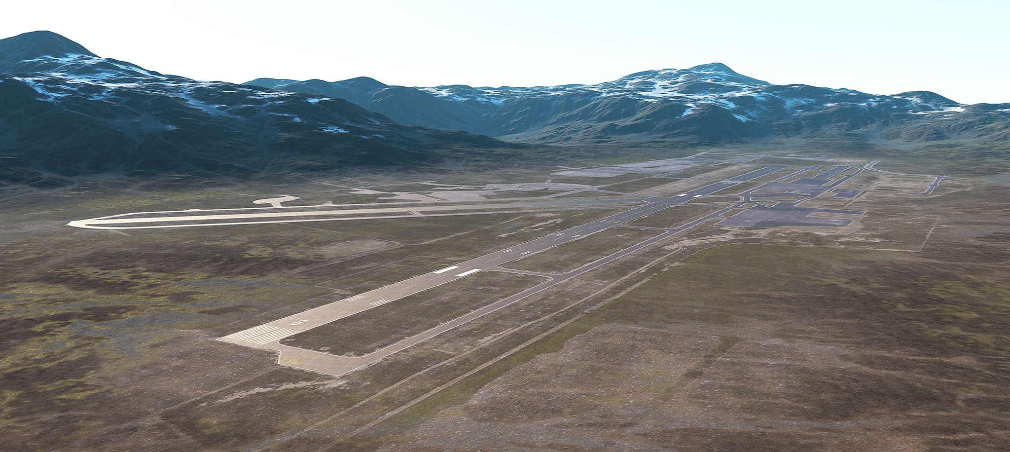
- You can flatten the a terrain area where the airport is located via a Houdini asset. Simple asset will use a custom mask to flatten areas during landscape generation.你可以平坦的地形区域机场所在的位置通过Houdini资源。简单资源将使用自定义蒙版在景观生成过程中压平区域。
-
Runway itself should be created using Mesh Decals or separate geometry. Use the same way to create lines and markings on the runways.跑道本身应该使用 Mesh Decals或单独的几何体创建。 使用相同的方法在跑道上创建线条和标记。For more detailed and visualized explanation of using Mesh Decals see a part of our video tutorial on Decals.更详细的和可视化解释使用Mesh Decal看到我们视频教程的一部分Decals 。
本页面上的信息适用于 UNIGINE 2.20 SDK.