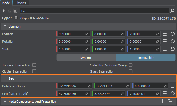
地理坐标
When working with models of the real world in your application with a georeferenced terrain, it is natural to position nodes using their geo-coordinates (latitude, longitude, altitude) instead of X, Y, and Z coordinates.在应用程序中使用具有地理参考地形的真实世界模型时,使用其地理坐标(纬度,经度,海拔)而不使用X,Y和Z坐标来定位节点是很自然的。
Geo-coordinates can be specified for any node that meets either of the following requirements:可以为满足以下要求之一的任何节点指定地理坐标:
- It is positioned in the world with a georeferenced terrain generated using the Sandworm tool.它被定位在使用Sandworm工具生成的地理参考地形中。
- It is added as a child to the GeodeticPivot node.它作为子节点添加到GeodeticPivot节点。
Geo Parameters地理参数#
This section describes parameters allowing you to specify the geo-coordinates of a node via UnigineEditor, along with obtain the origin of the world in geodetic coordinates.本节描述了允许您通过UnigineEditor指定节点的地理坐标的参数,以及在大地坐标中获得世界的原点。

| Database Origin | Origin of the world in geodetic coordinates (not editable).大地坐标中的世界原点(不可编辑)。 |
|---|---|
| Geo (Lat, Lon, Alt) | Latitude, longitude, and altitude coordinates of the node.节点的纬度、经度和高度坐标。 |
The set of available parameters varies depending on the node/nodes selected in the world:可用参数集取决于世界上选择的节点:
-
If you select the georeferenced terrain node, only the Database origin parameter will be available.如果选择地理参考地形节点,则只有Database origin参数将可用。

-
If you select any other node or multiple nodes, the Database origin and Geo parameters will be available.如果选择其他任何一个或多个节点,则Database origin和Geo参数将可用。
注意In this case, you can edit the values of the Geo parameter.在这种情况下,您可以编辑Geo参数的值。
-
When selecting both the georeferenced terrain and a node/multiple nodes, the Database origin and Geo parameters will be available.选择地理参考地形和一个或多个节点时,Database origin和Geo参数将可用。
注意The Geo values aren't editable in this case.在这种情况下,Geo值不可编辑。
When the node is added as a child to the Geodetic Pivot node, the Make Curved button is available as well.当节点作为子节点添加到Geodetic Pivot节点时,Make Curved按钮也可用。
本页面上的信息适用于 UNIGINE 2.19 SDK.
