使用编辑器工具执行特定任务
 UnigineEditor tools are available via the Menu Bar: to open a tool window, choose Tools and click the required tool.可以通过菜单栏使用UnigineEditor工具:打开工具窗口,选择Tools,然后单击所需的工具。
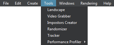
The following tools are available:提供以下工具:
- Landscape tool is used to create a global terrain according to provided geodata. The tool features the following:
- Processing real world elevation and imagery data by using the GDAL.Processing real world elevation and imagery data by using the GDAL.
- Using GIS data for procedural generation of details and vegetation, roads, communications, buildings, landmarks, and so on.Using GIS data for procedural generation of details and vegetation, roads, communications, buildings, landmarks, and so on.
- Supporting multiple data layers aligned by geo-coordinates and used for terrain LODs creation.Supporting multiple data layers aligned by geo-coordinates and used for terrain LODs creation.
- Processing real world elevation and imagery data by using the GDAL.使用GDAL处理现实世界的海拔和影像数据。
- Using GIS data for procedural generation of details and vegetation, roads, communications, buildings, landmarks, and so on.使用GIS数据以程序方式生成细节和植被,道路,通讯,建筑物,地标等。
- Supporting multiple data layers aligned by geo-coordinates and used for terrain LODs creation.支持通过地理坐标对齐并用于地形LOD创建的多个数据层。
- Video Grabber tool is used for capturing high-quality screenshots and frame sequences.
注意The Video Grabber tool is available only in the Engineering and Sim versions of UNIGINE SDK.Video Grabber工具用于捕获高质量的屏幕截图和帧序列。The Video Grabber tool is available only in the Engineering and Sim versions of UNIGINE SDK.The Video Grabber tool is available only in the Engineering and Sim versions of UNIGINE SDK.注意The Video Grabber tool is available only in the Engineering and Sim versions of UNIGINE SDK.Video Grabber工具仅在UNIGINE SDK的Engineering和Sim版本中可用。
- Impostors Creator tool is used to create impostors that are rendered instead of real objects. Impostors Creator工具用于创建冒充而不是真实物体的冒名顶替者。
- Randomizer tool is used for random placing of various objects (cars, houses, trees and so on) making the environment look more natural.Randomizer工具用于随机放置各种对象(汽车,房屋,树木等),使环境看起来更自然。
- Tracker tool is used for creating sequences animated over time that allows for adding dynamic gameplay elements or making in-game cinematic scenes.Tracker工具用于创建随时间变化的动画序列,允许添加动态游戏元素或制作游戏中的电影场景。
- Performance Profiler tool is used to display performance data in a timeline. It allows for detecting bottlenecks of an application and checking assets and code optimization results.Performance Profiler工具用于在时间轴上显示性能数据。它允许检测应用程序的瓶颈,并检查资产和代码优化结果。
最新更新:
2021-04-29
Help improve this article
Was this article helpful?
(or select a word/phrase and press Ctrl+Enter)