This page has been translated automatically.
Видеоуроки
Interface
Essentials
Advanced
Подсказки и советы
Программирование на C#
Рендеринг
Принципы работы
Свойства (properties)
Компонентная Система
Рендер
Физика
Редактор UnigineEditor
Обзор интерфейса
Работа с ассетами
Настройки и предпочтения
Работа с проектами
Настройка параметров узла
Setting Up Materials
Setting Up Properties
Освещение
Landscape Tool
Использование инструментов редактора для конкретных задач
Extending Editor Functionality
Встроенные объекты
Nodes
Objects
Effects
Decals
Light Sources
Geodetics
World Objects
Sound Objects
Pathfinding Objects
Players
Программирование
Основы
Настройка среды разработки
Примеры использования
UnigineScript
C++
C#
Унифицированный язык шейдеров UUSL
File Formats
Rebuilding the Engine Tools
GUI
Двойная точность координат
API
Containers
Common Functionality
Controls-Related Classes
Engine-Related Classes
Filesystem Functionality
GUI-Related Classes
Math Functionality
Node-Related Classes
Objects-Related Classes
Networking Functionality
Pathfinding-Related Classes
Physics-Related Classes
Plugins-Related Classes
IG Plugin
CIGIConnector Plugin
Rendering-Related Classes
Работа с контентом
Оптимизация контента
Материалы
Art Samples
Tutorials
Внимание! Эта версия документация УСТАРЕЛА, поскольку относится к более ранней версии SDK! Пожалуйста, переключитесь на самую актуальную документацию для последней версии SDK.
Внимание! Эта версия документации описывает устаревшую версию SDK, которая больше не поддерживается! Пожалуйста, обновитесь до последней версии SDK.

Quality

Warning
The functionality described in this article is not available in the Community SDK edition.
You should upgrade to Engineering / Sim SDK edition to use it.

Output quality affects the final resolution of the terrain (and consequently the disk space required). The set of quality settings depends on the type of the output terrain object.

Object Landscape Terrain#

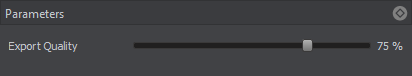
Export quality is from 1 to 100%. The percentage relates to the compression of the source data quality for the output. 100% quality means 0 compression, and reducing the quality value increases the compression.

Object Terrain Global#

The Sandworm tool defines the number of LODs, their visibility distances and densities automatically. You can change these settings individually for elevation, imagery, and details, if necessary. To modify LOD settings for the required data layer, disable the Automatic mode by unchecking the corresponding option.

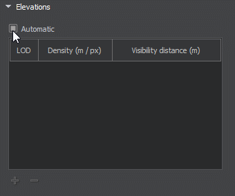
In the manual mode you can modify the Density and Visibility Distance values by double-clicking on the corresponding cell and entering the required value.

Use the + (plus) button to add a LOD, or - (minus) to remove one.

Notice
In the manual mode, the LOD density should be specified more accurately, as this value determines the size of the tileset of the generated LOD: the higher the LOD density, the bigger the LOD tileset (the density is multiplied by 128 — the size of a single tile). Specifying high values may lead to visual artifacts at the edges of the terrain.
Last update: 09.04.2021
Build: ()