Quality
 Output quality affects the final resolution of the terrain (and consequently the disk space required). The set of quality settings depends on the type of the output terrain object.输出质量会影响地形的最终分辨率(进而影响所需的磁盘空间)。质量设置集取决于输出地形对象.
Object Landscape Terrain对象 风景 地形#
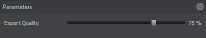
Export quality is from 1 to 100%. The percentage relates to the compression of the source data quality for the output. 100% quality means zero compression. Reducing the quality value increases the compression: with 50%, the original value will be halved, i.e., if you added the source elevation data with the size of 16k and set 50% export quality, the exported terrain will have a heightmap with 8k resolution.出口质量从 1% 到 100%。该百分比与输出的源数据质量的压缩有关。 100% 质量意味着 0 压缩。降低质量值会增加压缩:如果设置50%,原始值将被减半,也就是说,如果你添加了16k大小的源高程数据,并设置50%的输出质量,输出的地形将得到8k分辨率的高程图。
This compression is applied to any raster data (imagery, elevation, and masks). Vector data are not affected.这种压缩适用于任何栅格数据(图像、高程、掩码)。向量数据不受影响。
Object Terrain Global对象地形全局#
The Sandworm tool defines the number of LODs, their visibility distances, and densities automatically. You can change these settings individually for elevation, imagery, and details, if necessary. To modify LOD settings for the required data layer, disable the Automatic mode by unchecking the corresponding option.Sandworm 工具自动定义 LOD 的数量、它们的可见距离和密度。如有必要,您可以单独更改高程、图像和细节的这些设置。要修改所需数据层的 LOD 设置,请通过取消选中相应选项来禁用 Automatic 模式。
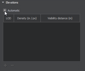
In the manual mode, you can modify the Density and Visibility Distance values by double-clicking on the corresponding cell and entering the required value.在手动模式下,您可以通过双击相应的单元格并输入所需值来修改 Density 和 Visibility Distance 值。
Use the + (plus) button to add a LOD, or - (minus) to remove one.使用 +(加号)按钮添加一个 LOD,或使用 -(减号)按钮删除一个。
In the manual mode, the LOD density should be specified more accurately, as this value determines the size of the tileset of the generated LOD: the higher the LOD density, the bigger the LOD tileset (the density is multiplied by 128 — the size of a single tile). Specifying high values may lead to visual artifacts at the edges of the terrain.在手动模式下,应更准确地指定 LOD 密度,因为该值决定了生成的 LOD 的图块集:LOD 密度越高,LOD 图块集越大(密度乘以 128 — 单个图块的大小)。指定高值可能会导致地形边缘出现视觉伪影。