Projection
 Output Projection is the projection to be used for the generated terrain. The set of options depends on the output format.输出 Projection 是用于生成地形的投影。选项集取决于 output format。
Object Landscape Terrain对象 风景 地形#
The generated terrain is exported to Object Landscape Terrain, which is actually a flat (i.e., not geospherical) area. Therefore, only projected coordinate systems are available for selection and can be used as export projections.生成的地形输出到Object Landscape Terrain,这实际上是一个平坦的(即非地球)区域。因此,只有投影坐标系可供选择并可用作导出投影。
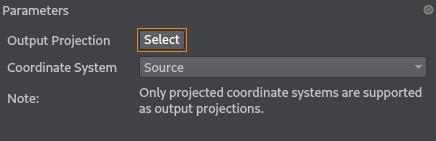
To choose a projection, click the corresponding button. The list of coordinate systems that can be used for projected output will open:要选择投影,请单击相应的按钮。可用于投影输出的坐标系列表将打开:
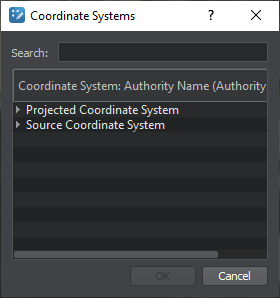
- The Projected Coordinate System list contains a wide range of coordinate reference systems for projected output.Projected Coordinate System 列表包含用于投影输出的各种坐标参考系统。
- The Source Coordinate System list displays the coordinate systems used by your source data for convenience.为方便起见,Source Coordinate System 列表显示源数据使用的坐标系。
Select a projection by double click, or just select by clicking once and press the OK button.通过双击选择一个投影,或者只需单击一次并按下 OK 按钮来选择。
For the proper terrain generation, the coordinate system that encompasses all data sources should be selected. If the selected coordinate system does not include any part of the source data, the part of the terrain for such fragment will not be generated.为了正确生成地形,应选择包含所有数据源的坐标系。如果所选坐标系不包含源数据的任何部分,则不会生成此类片段的地形部分。Object Terrain Global全球地形#
The following types of output projections are available:可以使用以下类型的输出投影:
- Built-In (Geodetic Pivot) projection based on WGS-84 ellipsoid.内置 (大地坐标轴)基于 WGS-84 椭球的投影。
- Custom projection that is used for data with a custom source projection (not WGS-84 ellipsoid-based). In this case, the projection is selected the same way as for Object Landscape Terrain.
注意The terrain generated using a custom projection cannot be curved.风俗 projection that is used for data with a custom source projection (not WGS-84基于椭球)。在这种情况下,投影的选择方式与Object Landscape Terrain.