Sandworm
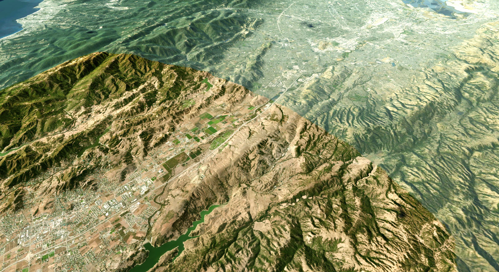
 The Sandworm tool is used to generate georeferenced terrain of any form using the provided data sources. This tool helps to quickly re-create portions of the real world by projecting them onto a flat Landscape Terrain Object or Object Terrain Global that supports Curved mode and natively works with geo-coordinates. The maximum terrain size depends on the available memory and data density, but typically, it's enough to create a big city or country landscape.Sandworm 工具用于使用提供的数据源生成任何形式的地理参考地形。该工具通过将它们投影到支持 Curved 模式并在本机使用地理坐标的平面 Landscape Terrain Object 或 Object Terrain Global 上,帮助快速重建现实世界的部分。地形的最大大小取决于可用内存和数据密度,但通常足以创建大城市或国家的景观。
The list of Sandworm features currently includes the following:Sandworm 功能列表目前包括以下内容:
- Support for multiple georeferenced sources: raster (elevation, imagery, and masks) and vector (roads, buildings, etc.)支持多个地理参考源:栅格(高程、图像和蒙版)和矢量(道路、建筑物等)
- Advanced data filtering options: via attributes (vector sources), via indexed, color, and channel masks (raster sources)高级数据过滤选项:通过属性(矢量源)、通过索引、颜色和通道掩码(光栅源)
- Support for online TMS (Mapbox, OSM) and offline data sources支持在线TMS (Mapbox, OSM)和离线数据源
- Mask-based generation of vegetation基于掩码的植被生成
- Generation of additional details (sand, rocks, etc.) based on landcover data for more realistic landscape surfaces基于土地覆盖数据生成更多细节(沙子、岩石等)以获得更逼真的景观表面
- Procedural generation of objects (roads, powerlines, buildings, landmarks, etc.)对象的程序生成(道路、电力线、建筑物、地标等)
- Advanced control and fine-tuning of placement parameters贴装参数的高级控制和微调
- Support for most of the widely used Coordinate Reference Systems (CRS) for input as well as output projections支持大多数广泛使用的坐标参考系统 (CRS) 用于输入和输出投影
- Ability to combine sources with different projection types within a single project能够在单个项目中组合具有不同投影类型的源
- Export to Landscape Terrain and Terrain Global导出到 Landscape Terrain 和 Terrain Global
- Coherent and user-friendly interface with dockable windows具有可停靠窗口的连贯且用户友好的界面
Sandworm generates a terrain using height map (elevation) and albedo (imagery) data provided. You can use the following types of data sources:Sandworm 使用提供的高度图(海拔)和反照率(图像)数据生成地形。您可以使用以下类型的数据源:
- Offline — locally stored tilesets: raster (elevation, imagery, and masks) and vector data sources from your local storage deviceOffline — 本地存储的瓦片集:来自本地存储设备的栅格(高程、图像和蒙版)和矢量数据源
- Online — Tile Map Services (TMS): you can connect to both open services (such as OpenStreetMap or various state/municipal databases) or private tile servers created and supported by users based on services similar to QGIS (currently supported data from online sources: imagery and elevation). Online — Tile Map Services (TMS):您可以连接到开放服务(例如 OpenStreetMap 或各种州/市政数据库)或用户基于类似于 QGIS 的服务创建和支持的私有瓦片服务器(目前支持的数据来自在线资源:图像和海拔)。
Georeferenced imagery and elevation data are processed using GDAL — Geospatial Data Abstraction Library. It supports various raster formats with different map projections for input data. It is also possible to combine different projection types and data sources to generate a terrain.地理参考图像和高程数据使用 GDAL — 地理空间数据抽象库进行处理。它支持各种栅格格式,输入数据具有不同的地图投影。还可以组合不同的投影类型和数据源来生成地形。
Sandworm uses GDAL for data processing, therefore, supported formats include those marked Built-in by default in the following lists:Sandworm 使用 GDAL 进行数据处理,因此支持的格式包括以下列表中标记为 Built-in by default 的格式:
这些数据源通常包含大量可以使用属性过滤器进行标记和过滤的信息。
标签表示颜色(颜色范围)或属性值(值范围),用于过滤生成某些土地覆盖区域或文化层对象(道路、建筑物)所需的数据。对于每个标记,您可以指定一组属性过滤器以从数据源中选择某些数据。您可以为每个标签指定任意数量的过滤器。标签用于在地形上放置对象。例如,通过使用标签,您可以:
- Generate grass or trees for areas marked with specific colors of the landcover texture.为标有某些颜色的土地覆盖纹理的区域生成草或树。
- Generate only highways ignoring small roads using a road type Attribute in a vector data file.使用矢量数据文件中的道路类型属性仅生成高速公路而忽略小路。
- Generate buildings of a particular type only (e.g., apartments, garages, single- or multi-story buildings, depending on the data stored in the vector data source).仅生成某种类型的建筑物(例如,公寓、车库、单层或多层建筑物,具体取决于矢量数据源中存储的数据)。
Sandworm supports multiple data layers aligned by geo or raster coordinates: you can easily create high-resolution insets by adding a high-detailed landscape area over a low-detailed one. This can be useful for flight simulators, where a high level of detail is required only for areas around airports. The quality of generated terrain is determined by the density of the data sources used.Sandworm 支持按地理或栅格坐标对齐的多个数据层:您可以通过在低细节的景观区域上添加高细节的景观区域来轻松创建高分辨率插图。这对于飞行模拟器非常有用,因为只有机场周围的区域才需要高细节。生成地形的质量取决于所使用数据源的密度。
High-detailed inset over a low-detailed area低细节区域的高细节插图See Also也可以看看#
- Article on Landscape Terrain关于 Landscape Terrain 的文章
- Documentation on the GDAL libraryGDAL 库的文档
- Wikipedia article on Equirectangular projection维基百科上关于 Equirectangular 投影的文章