GeodeticPivot Class
| Inherits from: | Node |
This class is used to create and modify a geodetic pivot object that is used to place world objects on their real world positions (latitude, longitude and altitude). The geodetic pivot contains an ellipsoid with a pivot point.
If you for any reason need to obtain the entity transforms (such as the position and rotation of your plane) to use them for configuring a camera on this entity or any beam emitted by this entity back to the ground, or anything similar, you need to consider the following while using Geodetic Pivot:
-
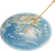
The Up axis starts at the estimated center of the ellipsoid Earth model and is directed outwards.
-
When the object is shifted upwards along this axis, its world coordinates X and Y will also change relative to the projected terrain (expected direction - grey line, actual direction - orange line).
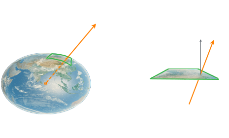
Thus, if we use directly the transforms obtained from the engine (for example, the world coordinates of the plane to orient the camera), the result will differ from what is expected.
- To obtain the corrected (and expected) transformations, you need to set the normal to Geodetic in the corresponding method (toWorld(), toWorldPreserveRotation()), the requried recalculations will be performed automatically.
Here is an example of a simple converter that allows transforming geodetic coordinates to world coordinates and vice versa:
class Converter
{
public:
	static Converter *get()
	{
		static Converter instance;
		return &instance;
	}

	void init()
	{
		geodetic_pivot = static_ptr_cast<Unigine::GeodeticPivot>(Unigine::World::getNodeByType(Unigine::Node::GEODETIC_PIVOT));
		if (geodetic_pivot)
		{
			Unigine::ObjectTerrainGlobalPtr terrain_global = static_ptr_cast<Unigine::ObjectTerrainGlobal>(Unigine::World::getNodeByType(Unigine::Node::OBJECT_TERRAIN_GLOBAL));
			is_curved_terrain = terrain_global && terrain_global->findAncestor(Unigine::Node::GEODETIC_PIVOT) != -1;
		}

		inited = geodetic_pivot.isValid();
	}

	Unigine::Math::dvec3 worldToGeodetic(const Unigine::Math::Vec3 &world_pos) const
	{
		UNIGINE_ASSERT(inited && "Converter is not initialized!");

		if (is_curved_terrain)
			return geodetic_pivot->toGeodetic(translate(world_pos));
		return geodetic_pivot->mapFlatToGeodetic(world_pos);
	}

	Unigine::Math::Vec3 geodeticToWorld(const Unigine::Math::dvec3 &geo_pos) const
	{
		UNIGINE_ASSERT(inited && "Converter is not initialized!");

		if (is_curved_terrain)
			return Unigine::Math::Vec3(geodetic_pivot->toWorld(geo_pos).getTranslate());
		return Unigine::Math::Vec3(geodetic_pivot->mapGeodeticToFlat(geo_pos));
	}

	Unigine::Math::Mat4 getZeroBasis(const Unigine::Math::dvec3 &geo_pos) const
	{
		UNIGINE_ASSERT(inited && "Converter is not initialized!");

		if (is_curved_terrain)
			return geodetic_pivot->toWorld(geo_pos, Unigine::GeodeticPivot::UP_AXIS_GEODETIC_NORMAL);

		// convert curved rotation to flat (forward.z = 0)
		Unigine::Math::dmat4 transform = geodetic_pivot->toWorld(geo_pos, Unigine::GeodeticPivot::UP_AXIS_GEODETIC_NORMAL);
		Unigine::Math::dvec3 up = Unigine::Math::dvec3_up;
		Unigine::Math::dvec3 forward = transform.getColumn3(1);
		forward.z = 0;
		forward = normalize(forward);
		Unigine::Math::dvec3 right = cross(forward, up);
		transform.setColumn3(0, right);
		transform.setColumn3(1, forward);
		transform.setColumn3(2, up);
		return Unigine::Math::Mat4(transform);
	}

private:
	Converter() = default;
	~Converter() = default;

	bool inited = false;
	bool is_curved_terrain = false;
	Unigine::GeodeticPivotPtr geodetic_pivot;
};
To use this Converter class:
Converter::get()->init(); // called in world::init

// anywhere in code
Conveter::get()->worldToGeodetic ...
See also#
A UnigineScript API sample <UnigineSDK>/data/samples/geodetics/pivot_00
GeodeticPivot Class
Members
static GeodeticPivot ( ) #
GeodeticPivot constructor. Creates a GeodeticPivot instance with the default settings:- The origin is set to dvec3(0.0,0.0,0.0).
- The size of the curving region is 2048000×2048000 km.
- The resolution of the region texture is 2048.
void setEllipsoid ( Ellipsoid ellipsoid ) #
Sets an Ellipsoid to be used for the Geodetic Pivot.// Creating a new geodetic pivot
GeodeticPivot pivot = new GeodeticPivot();
// setting the local (X - Y - Z) origin basis for it
pivot.setOriginBasis(GEODETIC_PIVOT_ORIGIN_BASIS_LOCAL);
// getting an ellipsoid currently used by the geodetic pivot
Ellipsoid ellipsoid = pivot.getEllipsoid();
// setting a fast calculation mode for the ellipsoid
ellipsoid.setMode(ELLIPSOID_MODE_FAST);
// setting a new semimajor axis for the ellipsoid
ellipsoid.setSemimajorAxis(6378137.0f - 500.0f);
/* ... */
// force updating the geodetic pivot according to the modified ellipsoid
pivot.setEllipsoid(ellipsoid);Arguments
- Ellipsoid ellipsoid - Ellipsoid to be set.
getEllipsoid ( ) #
Returns the Ellipsoid currently used by the Geodetic Pivot.// Creating a new geodetic pivot
GeodeticPivot pivot = new GeodeticPivot();
// setting the local (X - Y - Z) origin basis for it
pivot.setOriginBasis(GEODETIC_PIVOT_ORIGIN_BASIS_LOCAL);
// getting an ellipsoid currently used by the geodetic pivot
Ellipsoid ellipsoid = pivot.getEllipsoid();
// setting a fast calculation mode for the ellipsoid
ellipsoid.setMode(ELLIPSOID_MODE_FAST);
// setting a new semimajor axis for the ellipsoid
ellipsoid.setSemimajorAxis(6378137.0f - 500.0f);
/* ... */
// force updating the geodetic pivot according to the modified ellipsoid
pivot.setEllipsoid(ellipsoid);Return value
Ellipsoid currently used by the Geodetic Pivot.void setOrigin ( dvec3 origin ) #
Sets a new position (latitude, longitude and altitude) on the ellipsoid.// the GeodeticPivot will use WGS84 reference ellipsoid by default
GeodeticPivot pivot = new GeodeticPivot();
// update the origin
dvec3 new_york_origin = dvec3(40.71427,-74.00597,57.0);
pivot.setOrigin(new_york_origin);
ObjectMeshStatic flat_new_york_ground = new ObjectMeshStatic("flat_new_york_ground.mesh");
pivot.addChild(flat_new_york_ground); // the mesh will be bent once ObjectMeshStatic become a child of GeodeticPivotArguments
- dvec3 origin - Origin vector in ellipsoid coordinates.
dvec3 getOrigin ( ) #
Returns the position (latitude, longitude and altitude) on the ellipsoid.Return value
Origin vector in ellipsoid coordinates.void setOriginBasis ( int basis ) #
Sets a new origin basis for the GeodeticPivot object:- If GEODETIC_PIVOT_ORIGIN_BASIS_LOCAL is set, the binding to geo-coordinates is disabled. GeodeticPivot can be placed everywhere.
- If GEODETIC_PIVOT_ORIGIN_BASIS_ENU is set, GeodeticPivot is placed to the world ECF position with ENU (East - North - Up) orientation according to the given latitude / longitude / altitude. The GeodeticPivot position is blocked.
NoticeThe Up-axis (Z+) direction in ENU points upward along the ellipsoid normal, while in UNIGINE implementation of ENU it goes from the Earth's center.
Arguments
- int basis
int getOriginBasis ( ) #
Returns the origin basis set for the GeodeticPivot object:- If GEODETIC_PIVOT_ORIGIN_BASIS_LOCAL is set, the binding to geo-coordinates is disabled. GeodeticPivot can be placed everywhere.
- If GEODETIC_PIVOT_ORIGIN_BASIS_ENU is set, GeodeticPivot is placed to the world ECF position with ENU (East - North - Up) orientation according to the given latitude / longitude / altitude. The GeodeticPivot position is blocked.
NoticeThe Up-axis (Z+) direction in ENU points upward along the ellipsoid normal, while in UNIGINE implementation of ENU it goes from the Earth's center.
Return value
dvec3 mapGeodeticToFlat ( dvec3 geodetic_coords ) #
Maps geodetic latitude / longitude / altitude coordinates to flat plane coordinates according to pivot's latitude / longitude / altitude origin.Arguments
- dvec3 geodetic_coords - Geodetic coordinates.
Return value
Flat plane coordinates.dmat4 toWorld ( dvec3 geodetic_coords, int up_axis = Enum.GeodeticPivot.UP_AXIS.GEOCENTRIC_NORMAL ) #
Returns world transformation matrix for given geodetic coordinates.Arguments
- dvec3 geodetic_coords - Geodetic coordinates.
- int up_axis - Type of the UP axis. If the obtained coordinates will be used to set the transforms for anything relative to the entity (such as camera on the plane or a laser beam from the plane), switch the up axis type to geodetic normal.
Return value
World transformation.static int type ( ) #
Returns the type of the object.Return value
GeodeticPivot type identifier.The information on this page is valid for UNIGINE 2.20 SDK.