创建地形
 In Sandworm, the terrain is generated based on georeferenced data (both offline and online). If you want to create a terrain using non-georeferenced data or sculpt it from scratch with brushes, you can do that right in UnigineEditor; the Sandworm tool is not required.在 Sandworm 中,地形是根据地理参考数据(离线和在线)生成的。如果您想使用非地理参考数据创建地形,或从头开始雕刻刷子你可以这样做就在 UnigineEditor , Sandworm 工具不是必需的。
1. Specifying Data Source Type1. 指定数据源类型#
To generate the terrain surface in its basic form, you need to add the following types of source data:要以基本形式生成地形表面,需要以下类型的源数据:
- Elevation / Height — data used to generate terrain geometry.Elevation / Height — 用于生成地形几何的数据
- Imagery / Color — data used to generate textures for the terrain surface.Imagery / Color — 用于生成地形表面纹理的数据
2. Specifying Data Source Parameters2. 指定数据源参数#
When you select a data source, you can see its parameters in the Parameters panel. The contents of this panel differ depending on the layer type:当您选择一个数据源时,您可以在 Parameters 面板中看到它的参数。此面板的内容因图层类型而异:
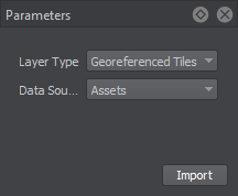
- Georeferenced Tiles — for adding offline data stored on the PC.Georeferenced Tiles — 用于添加存储在 PC 上的离线数据。
- TMS — for using online data by adding the link.TMS — 通过添加链接使用在线数据。
The TMS data source is currently available for Elevation and Imagery layers only.TMS 数据源目前仅可用于 Elevation 和 Imagery 层。Offline Data Sources离线数据源#
If you upload data stored on the PC, use the Georeferenced Tiles layer type.要使用存储在 PC 上的数据,应使用 Georeferenced Tiles 层类型。
-
Select the data source type:选择数据源类型:
-
Assets — files that are added to the file system and represent a part of the project. Depending on the size of assets, they can be stored in the /data directory or added as a mount. This approach is recommended for teamwork.Assets — 添加到文件系统并且是项目的一部分。根据资产的大小,它们可以存储在 /data 目录中或作为 mount 添加。这种方法特别推荐用于团队工作。注意We recommend importing image files as Unchanged, in order to avoid creating the unnecessary runtime files.建议将图像文件导入为 Unchanged,以避免创建不必要的运行时文件。
- External Files, which are not a part of the file system. This type of data source may be helpful if the file extension is unknown to the file system. However, keep in mind that if you share this project, the path to the external file has to be updated accordingly.External Files,它不是文件系统的一部分。如果文件系统不知道文件扩展名,这种类型的数据源可能很有用。但是,请记住,如果您共享此项目,则必须相应地更新外部文件的路径。
-
-
Click Import. The dialog window will open to set the path to the data source. If the data source consists of several files/assets, select them all, and they will be added as separate layers.单击 Import。对话窗口将打开以设置数据源的路径。如果数据源由多个文件/资产组成,请将它们全部选中,它们将作为单独的图层添加。注意The preview generation process may take much time for heavy source files, therefore you can cancel it, and generate later, if that is required.对于大量源文件,预览生成过程可能需要很长时间,因此您可以取消它, 和稍后生成,如果需要的话。
For the imported offline source layers, the following parameters are available:对于已导入的离线源层,可选择如下参数:
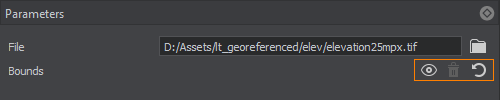
 |
Encloses the area visible in the Preview window in the bounds. The data will be uploaded for the area within these bounds. You can move the points defining the bounds to adjust the area as necessary.在边界内封闭预览窗口中可见的区域。数据将上传这些范围内的区域。您可以移动定义边界的点,根据需要调整区域。 |
|---|---|
 |
Removes the bounds for the selected layer. If the bounds are not set, all data available in the layer and within the Export Area will be uploaded.移除所选图层的边界。如果没有定义边界,图层和Export Area中的所有数据都将被上传。 |
 |
Sets the bounds to enclose all data available in the layer. The data will be uploaded for the area within these bounds. You can move the points defining the bounds to adjust the area as necessary.设置边界以包含层中所有可用的数据。数据将上传这些范围内的区域。您可以移动定义边界的点,根据需要调整区域。 |
Using this toolset, you can define which data should be taken from every layer without uploading unnecessary or corrupted data.通过使用这个工具集,您可以定义应该从每个层获取哪些数据,而无需上传任何不必要的或损坏的数据。
Online Data Sources在线数据源#
The TMS layer type is designed for using Tile Map Services for terrain generation. This option is available for the Elevation and Imagery data types.TMS 图层类型旨在使用 Tile Map Services 进行地形生成。此选项可用于 Elevation 和 Imagery 数据类型。
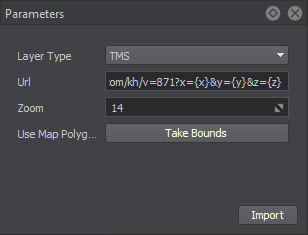
对于在线数据,应设置以下参数:
| URL |
注意
The sources that require login and password input are currently not supported.目前不支持需要登录和密码输入的来源。 |
|---|---|
| Zoom | Zoom level that specifies the scale of the area map to be downloaded. Data providers have their own zoom levels defined; therefore, this value depends on the source. For example, OSM has the following zoom levels.缩放级别,指定要下载的区域地图的比例。数据提供者定义了自己的缩放级别,因此,该值取决于源。例如,OSM 有以下内容缩放级别。
|
| Take Bounds | Encloses the area visible in the Preview window in the boundaries (green frame). The data will be uploaded for the area within these boundaries. The position of the tags defining the boundaries can be modified as required.将预览窗口中可见的区域包围在边界(绿框)中。将为这些范围内的区域上传数据。可以根据需要修改定义边界的标签的位置。 |
After the data parameters are set, click Import, and the data preview will be displayed. In case of heavy data, the display of the preview may take some time.数据参数设置好后,点击Import,会显示数据预览。在大量数据的情况下,预览的显示可能需要一些时间。
The preview generation process may take much time for heavy source files, therefore you can cancel it, and generate later, if that is required.对于大量源文件,预览生成过程可能需要很长时间,因此您可以取消它, 和稍后生成,如果需要的话。3. Adding vegetation3. 添加植被#
At this step, you can determine which natural features of the terrain are to be generated.在此步骤中,您可以确定要生成地形的哪些自然特征。
-
The Mask data source type allows using Grass and Mesh Clutter to generate and place vegetation or other objects in specific areas of the terrain according to filtered landcover data.Mask 数据源类型允许使用 Grass 和 Mesh Clutter 根据指定的土地覆盖标记在地形的某些区域生成和放置植被或其他对象。Workflow: Generating Vegetation.工作流程:生成植被.
-
Terrain details — the data filtered from landcover data sources to identify areas for terrain details to be added.地形细节——标签指定用于确定要放置地形详细信息的区域的土地覆盖数据源。Workflow: Generating Details.工作流程:生成详细信息.
You may skip this step, if you don't need procedural generation of natural features of the terrain for your project.如果您的项目不需要程序生成地形的自然特征,则可以跳过此步骤。4. Setting Up Cultural Layer4. 建立文化层#
The Vector data source type is used to generate cultural features of the terrain: roads, communications, fences, pipes, buildings, landmarks, etc.Vector 数据源类型用于生成地形的文化特征:道路、通信、围栏、管道、建筑物、地标等。
Objects of the cultural layer are divided into three groups depending on the type of vector data used for their generation:文化层的对象根据生成时使用的矢量数据类型分为 3 组:
-
Vector (Roads) — objects of this type are generated and placed along vectors.Vector (Roads) — 这种类型的对象是沿着向量生成和放置的。Workflow: Generating Roads.工作流程:生成道路.
-
Point (Buildings, Landmarks, etc.) — objects of this type are generated and placed at specific points.Point(建筑物、地标等)——生成并放置此类对象。Workflow: Generating Point Objects.工作流程:生成点对象.
- Buildings — objects of this type are generated on the basis of Open Street Maps (OSM).Buildings — 这种类型的对象是在 Open Street Maps (OSM) 的基础上生成的。Workflow: Generating Buildings.工作流程:生成建筑物.
You may skip this step, if you don't need procedural generation of cultural features of the terrain for your project.如果您不需要为您的项目程序生成地形的文化特征,您可以跳过此步骤。5. Generating a Terrain5. 生成地形#
To generate a terrain, you need to define the output settings, such as the type of object that will be used for the terrain and the world that will store this object.要生成地形,您需要定义输出设置,例如将用于地形的对象的类型以及将存储此对象的世界。
Then you can generate the terrain by clicking the Generate button.那么你就可以产生通过单击 Generate 按钮查看地形。
A terrain fragment will be generated based on the input data and specified output settings in the world that we set as the output one.地形片段将根据输入数据和我们设置为输出世界的指定输出设置生成。