Landscape Tool
Landscape Tool is used to create rectangular sized terrain areas according to provided data sources, but it cannot be used to create a whole planet. This tool helps to create up to 10000km x 10000km areas of the real world: it's enough to create a terrain of a big city or a country.
Landscape Tool generates a terrain using height map (elevation) and albedo (imagery) data provided. You can use the following types of data sources:
- Ordinary raster images to create an arbitrary terrain according to your own preferences.
- Geo-referenced ones (GIS data) to create a fragment of Earth's surface.
Geo-referenced imagery and elevation data are processed by using the GDAL - Geospatial Data Abstraction Library. It supports various raster formats with different map projections for input data.
The data sources support the following formats:
- RGB and RGBA formats for albedo (imagery) data. Alpha-channel in the second case is used to mark no data areas.
- R format for height maps (elevation sources).
- R and RGBA formats for masks (landcover sources).
GIS data sources can be used for generation of details and vegetation (raster data), roads, communications, buildings, landmarks, etc. (vector data). These data sources usually contain a lot of information.
- generate grass for areas marked with certain colors of the landcover texture,
- generate only highways ignoring small roads using a road type attribute in a vector data file.
Landscape Tool supports multiple data layers aligned by geo or raster coordinates: you can easily create high-resolution insets by adding a high-detailed landscape area over a low-detailed one. The quality of generated terrain is determined by the density of the data sources used.
A flexible procedural refinement system, offered by the Landscape Tool, makes it possible to improve generated terrain using Houdini Digital Assets for more realistic visual representation.
Overview
The Landscape tool has 4 panels (Settings, Sources, Preview and Parameters panels) and the Generate button.
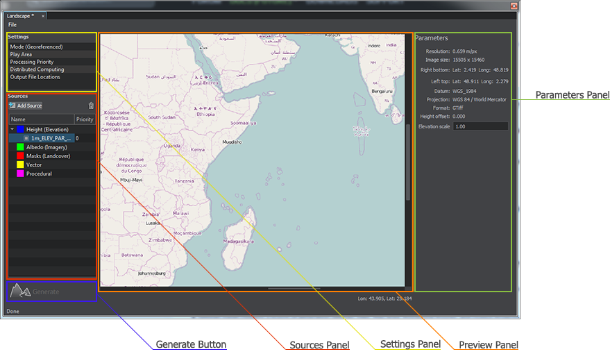
- In the Sources panel, you should specify the height (elevation) and albedo (imagery) sources for the terrain generation, as well as masks (landcover), vector and procedural data sources for generation of details, vegetation, roads, communications, buildings, etc. if necessary.
- Selecting the Height (Elevation) or Albedo (Imagery) group provides access to Terrain LODs of this type of the data source.
- Selecting the Masks (Landcover) group provides access to Terrain LODs of this data source type, as well as to Detail Masks and Vegetation settings.
- Selecting the Vector group provides access to settings for cultural features of the landscape such as roads and communications, fences, pipes, etc.
- Settings panel contains a bunch of generation settings: Mode, Play Area, Processing Priority, Distributed Computing and Output File Locations.
- In the Preview panel, you can specify the play area of the landscape generation. In the georeferenced mode, the preview panel depicts the world map in the equirectangular projection.
- Parameters panel depicts parameters of the selected settings or information of the selected data source.
See Also
- The Global terrain article.
- The documentation on the GDAL library.
- The Wikipedia article on Equirectangular projection.