Projection
In this section you select the projection to be used for the generated terrain and the required alignment of axes in the coordinate system.在本节中,您选择用于生成的地形和投影坐标system.所需的轴对齐

Output Projection输出投影#
The generated terrain is exported to Object Landscape Terrain or Object Terrain Global, which is actually a flat (i.e., not geospherical) area. Therefore, only projected coordinate systems are available for selection and can be used as export projections.生成的地形被导出到Object Landscape Terrain或Object Terrain Global,这实际上是一个平坦(即,不是地球形)区域。因此,只有投影坐标系可供选择,可以用作输出投影。
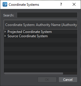
To choose a projection, click the corresponding button. The list of coordinate systems that can be used for projected output will open:选择一个投影,单击相应的按钮。坐标系统的列表,可用于预测输出将打开:

- The Projected Coordinate System list contains a wide range of coordinate reference systems for projected output.Projected Coordinate System列表包含大量用于投影输出的坐标参考系统。
- The Source Coordinate System list displays the coordinate systems used by your source data for convenience.Source Coordinate System列表显示你的源数据方便使用的坐标系统。
Select a projection by double click, or just select by clicking once and press the OK button.通过双击选择投影,或者只通过单击一次选择并按下OK按钮。
Coordinate System坐标系统#
The result of data transformation using the selected projection sometimes may not coincide with the internal UNIGINE axis alignment (East(x), North(y)). In such a case, the generated terrain might differ from the preview (i.e., East and West switched). To fix this, set the Coordinate System to Source.使用所选投影进行数据转换的结果有时可能与内部 UNIGINE 轴对齐(East(x), North(y))不一致。 在这种情况下,生成的地形可能与预览不同(即东西方互换)。 要解决此问题,请将 Coordinate System 设置为 Source。
- Source — the orientation of the generated terrain is in accordance with the alignment indicated in the projection.Source -生成地形的方向是按照对齐显示在投影。
- World — the generated terrain is aligned as East(x), North(y).World -生成的地形对齐为东(x),北(y)。
Built-In (Unigine Projection)Built-In (Unigine投影)#

Built-In (Unigine Projection) is an additional option available for the Object Terrain Global terrain type only. The terrain is generated using the projection based on WGS-84 ellipsoid and can be curved.内置(Unigine投影)是Object Terrain Global 地形类型唯一可用的附加选项。地形是使用基于WGS-84椭球体的投影生成的,可以是曲线。
