Geodetic Pivot
A Geodetic Pivot object is an abstract object that contains an ellipsoid with a pivot point. By using Geodetic Pivot you can place objects on the scene on the corresponding places in the real world.Объект Geodetic Pivot — это абстрактный объект, содержащий эллипсоид с точкой вращения. Используя Geodetic Pivot, вы можете размещать объекты на сцене в соответствующих местах реального мира.
Geodetic Pivot helps to place world objects on their real world positions (latitude, longitude and altitude) by curving a plane with objects on it. Pivot converts real geodetic data to Cartesian and simultaneously "curves" objects to simulate the contorted Earth's surface.Geodetic Pivot помогает размещать объекты мира в их реальных позициях (широте, долготе и высоте) путем искривления плоскости с объектами на ней. Pivot преобразует реальные геодезические данные в декартовы координаты и одновременно «изгибает» объекты для имитации искривленной поверхности Земли.
Geodetic Pivot works with:Geodetic Pivot работает с:
- ObjectTerrainGlobal
- ObjectWaterGlobal
- ObjectCloudLayer
- ObjectSky
- ObjectMeshStatic
- ObjectGrass
- ObjectMeshClutter
- WorldClutter
- Mesh Decals
See AlsoСмотрите также#
- The GeodeticPivot class to manage scenes with geodetic data via APIКласс GeodeticPivot для управления сценами с геодезическими данными через API.
- The render_show_geodetic_pivot console command to show Geodetic Pivots in the sceneКонсольная команда render_show_geodetic_pivot для отображения Geodetic Pivots в сцене
- A Wikipedia article on Ellipsoid Статья в Википедии о Эллипсоид
- A Wikipedia article on Geodesics on an ellipsoidСтатья в Википедии о Геодезические на эллипсоиде
Adding a Geodetic PivotДобавление Geodetic Pivot#
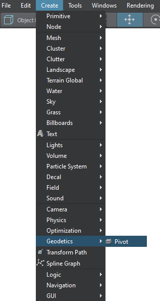
To add a Geodetic Pivot to the scene via UnigineEditor do the following:Чтобы добавить Geodetic Pivot в сцену через UnigineEditor, сделайте следующее:
Setting Up a Geodetic PivotНастройка Geodetic Pivot#
After adding the Geodetic Pivot on the scene, set up the parameters located in the Geodetic Pivot section (Parameters window -> Node tab).После добавления Geodetic Pivot на сцену настройте параметры, расположенные в разделе Geodetic Pivot (окно Parameters → вкладка Node).

Location settings. The geodetic location on the Earth of the pivot point. It is specified by 3 components:Настройки местоположения. The geodetic location on the Earth of the pivot point. It is specified by 3 components:
- Latitude is the north–south position in degrees of a point on the Earth's surface. For example, Tomsk city latitude is 56.4977100. 0 value means equator, 90 value means the North Pole, -90 means the South Pole.Latitude — положение с севера на юг в градусах точки на поверхности Земли. Например, широта города Томска 56.4977100. Значение 0 означает экватор, значение 90 означает северный полюс, -90 означает южный полюс.
- Longitude is the east-west position in degrees of a point on the Earth's surface. For example, Tomsk city longitude is 84.9743700. 0 value means a prime meridian (Greenwich). This field supports two ranges: from -180 to 180 and from 0 to 360.Longitude — положение точки на поверхности Земли с востока на запад в градусах. Например, долгота города Томска 84.9743700. Значение 0 означает нулевой меридиан (Гринвич). Это поле поддерживает два диапазона: от -180 до 180 и от 0 до 360.
- Altitude is the height above sea level of a location. For example, Tomsk city altitude is 117 meters.Altitude — высота местоположения над уровнем моря. Например, высота города Томска составляет 117 метров.
- Flat geopositioning mode of the Geodetic Pivot. This mode should be used, when it is necessary only to set node positions via geo coordinates (latitude, longitude, altitude) without curving the terrain, clouds, etc.Flat режим геопозиционирования Geodetic Pivot. Этот режим следует использовать, когда необходимо только задать положение узлов через геокоординаты (широта, долгота, высота) без искривления рельефа, облачности и т.п.
Ellipsoid settings.Настройки эллипсоида.
- Reference is a mathematically defined ellipsoid that approximates the surface of the planet. We offer popular geocentric reference ellipsoids: WGS84, GRS80, Airy 1830, etc.Reference — это математически определенный эллипсоид, который аппроксимирует поверхность планеты. Предлагаем популярные геоцентрические опорные эллипсоиды: WGS84, GRS80, Airy 1830и т.п.
Working with Geodetic PivotРабота с Geodetic Pivot#
After adding and setting up the Geodetic Pivot, you can simply add objects to "curve" them:После добавления и настройки Geodetic Pivot вы можете просто добавить объекты, чтобы «изгибать» их:
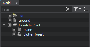
Choose the necessary nodes (Static Mesh, Grass, Clutter, etc.) in the Nodes window and set them as children of the Geodetic Pivot.Выберите нужные узлы (Static Mesh, Grass, Clutter и т.д.) в окне Nodes и установите их как дочерние узлы Geodetic Pivot.

- Specify the necessary settings of the Geodetic Pivot.Укажите необходимые настройки Geodetic Pivot.
- The update will be performed automatically.Обновление будет выполнено автоматически.
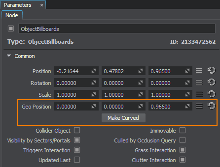
As you add a node as a child to the Geodetic Pivot, its geo position coordinates (latitude, longitude, and altitude) are displayed in the Common section of the Node tab:Когда вы добавляете узел в качестве дочернего в Geodetic Pivot, координаты его географического положения (широта, долгота и высота) отображаются в разделе Common на вкладке Node:

| Geo Position | Specifies the geo position coordinates for the node (latitude, longitude, and altitude).Указывает координаты географического положения узла (широта, долгота и высота). |
|---|---|
|
By default only the following objects are curved by the Geodetic Pivot:По умолчанию Geodetic Pivot изгибает только следующие объекты:
As for Static Meshes, Mesh Decals, and Billboards, sometimes you might just want to set their positions in real world coordinates an leave their geometry as is, but in some cases they should be curved (e.g., large static meshes, or roads represented as mesh decals). For this purpose you should use the following two buttons:Что касается Static Meshes, Mesh Decals, and Billboards, иногда вы можете просто захотеть установить их положение в реальных координатах и оставить их геометрию как есть, но в некоторых случаях они должны быть изогнутыми (например, большие статические сетки или дороги, представленные в виде декалей сетки). Для этого вы должны использовать следующие две кнопки: |
|
| Make Curved | Curves the geometry of the object according to the specified settings. A curved clone of the initial node is created, the initial node (using a non-curved mesh) is simply disabled, so you can use it when you need to return geometry back to normal (uncurved) state.Искривляет геометрию объекта в соответствии с заданными настройками. Создается криволинейный клон начального узла, начальный узел (использующий некриволинейную сетку) просто отключается, поэтому вы можете использовать его, когда вам нужно вернуть геометрию обратно в нормальное (некриволинейное) состояние. |


