Global Terrain
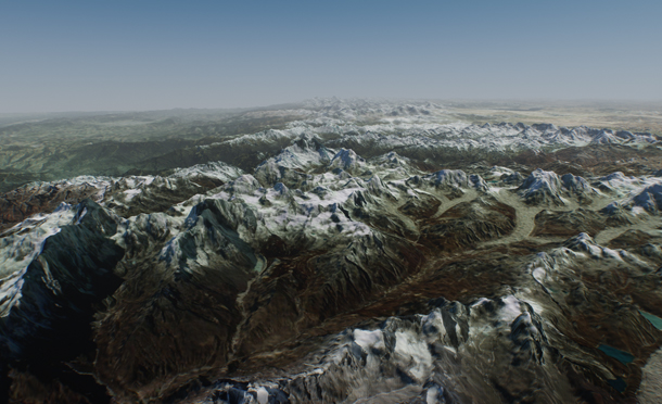
Global terrain is a virtually limitless terrain representing a certain fragment of Earth's surface generated on the basis of GIS data. This means that appearance of the global terrain object is determined by the accuracy and availability of geospatial data. It should be noted that there are areas of Earth's surface with only low-resolution data available or even no geospatial data at all.
This type of terrain can be successfully used for flight simulators: most of the time the plane remains at a very high altitude and low-resolution data is sufficient. High-resolution data is necessary only around landing and take-off areas.
- There can be only one Global Terrain object on the scene.
- Memory consumption increases significantly when several viewports are used.
See Also
- A terrain_global_base material.
- Global Terrain Details article to learn more about setting up visual representation of the global terrain.
- Landscape tool article to learn about global terrain generation.
- An ObjectTerrainGlobal class to edit global terrain via C++, C# or UnigineScript API.
- A Tileset class to manage tileset data of of the ObjectTerrainGlobal via C++, C# or UnigineScript API.
- A TilesetFile class to manage tileset files of the ObjectTerrainGlobal via C++, C# or UnigineScript API.
- A TilesetFile console tool to extract data from .UTS tileset files of the global terrain.
Terrain Structure
Global terrain is represented by the following data layers:
- Height data generated on the basis of GIS elevation data.
- Albedo data generated on the basis of GIS satellite imagery data.
- Normal data generated on the basis of height data.
- Masks data generated on the basis of landcover data.
Tiling
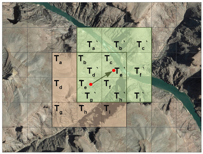
Global terrain has a regular grid and is represented as a tileset. Each tile has a fixed size of 128 x 128 pixels. The number of tiles in each dimension (X and Y) is determined by the area size and GIS data resolution. The higher the resolution the more tiles will be generated for the corresponding tileset.
E.g. suppose we have a height data texture with the resolution of 100 meters per pixel for an area of 50 square kilometers. Thus, we need (50000/100) x (50000/100) = 500 x 500 pixels which can be covered by 4 x 4 tiles.
The tiles around the viewpoint are loaded automatically according to visibility distance. Visible tiles change as the viewpoint moves along the terrain.
LODs
A level of detail (LOD) system automatically adapts the available resolution of terrain grid according to the distance and loads corresponding tiles.
Every particular data layer has its own number of LODs. Each LOD of a particular data layer is represented by a separate tileset and has a number of parameters according to data layer type. Each LOD has its own resolution (in meters per pixel) which determines the size of its tileset.
LODs are loaded and and cleared in accordance with corresponding distances specified in the TerrainGlobal tab. These distances are be used to avoid delays and provide smoothness when switching between LODs as well as to ensure efficient memory use.
Resolution and visibility distance together determine the number of tiles to be loaded around the viewpoint.
Blending of LODs
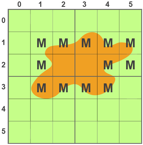
As it was mentioned, there might be no data available for a more detailed LOD of a certain area. In this case the values of the two adjacent LODs are blended together to provide a smooth look without sharp edges or black holes. Blending is performed by means of linear interpolation on the basis of masks generated by the Landscape Tool for a certain tile.
Let us consider the following example. Suppose we have two LODs:
- LOD1 with the resolution of 100 meters per pixel - green area.
- LOD0 with the resolution of 30 meters per pixel - orange area.
Creating a Global Terrain
You can only create a global terrain object using the Landscape Tool.
Please refer to the Creating a Terrain article to learn more about terrain generation in the Landscape Tool.
Terrain Parameters
Global terrain parameters can be adjusted via the TerrainGlobal tab of the Parameters window. Each data layer contains a list of LODs with corresponding parameters.
Height Data
Parameters of a certain LOD of the height data layer can be accessed via the Height LODs group of the TerrainGlobal tab of the Parameters window.
You can add a new LOD or remove an existing one by clicking Insert or Remove respectively.
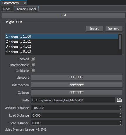
The following parameters are available for the Height LODs:
- Enabled - enable or disable the current height LOD.
- Intersectable - enable or disable intersection detection for the current height LOD.
- Collidable - enable or disable collision detection for the current height LOD.
- Viewport - viewport mask for the current height LOD.
- Intersection - intersection mask for the current height LOD.
- Collision - collision mask for the current height LOD.
- Path - path to a folder, in which the current height LOD is stored.
- Visibility distance - the distance starting from which the tiles of the current height LOD become visible.
- Load distance - the distance starting from which the tiles of the current height LOD are loaded into memory.
- Clear distance - the distance starting from which the tiles of the current height LOD are removed from memory.
- Video memory usage - memory consumption of the current height LOD.
Albedo Data
Parameters of a certain LOD of the albedo data layer can be accessed via the Albedo LODs group of the TerrainGlobal tab of the Parameters window.
You can add a new LOD or remove an existing one by clicking Insert or Remove respectively.
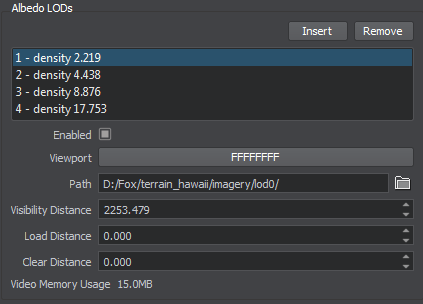
The following parameters are available for the Albedo LODs:
- Enabled - enable or disable the current albedo LOD.
- Viewport - viewport mask for the current albedo LOD.
- Path - path to a folder, in which the current albedo LOD is stored.
- Visibility distance - the distance starting from which the tiles of the current albedo LOD become visible.
- Load distance - the distance starting from which the tiles of the current albedo LOD are loaded into memory.
- Clear distance - the distance starting from which the tiles of the current albedo LOD are removed from memory.
- Video memory usage - memory consumption of the current albedo LOD.
Normal Data
Parameters of a certain LOD of the normal data layer can be accessed via the Normal LODs group of the TerrainGlobal tab of the Parameters window.
You can add a new LOD or remove an existing one by clicking Insert or Remove respectively.
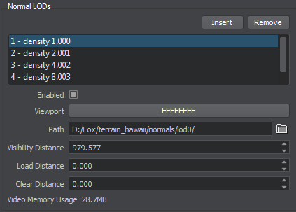
The following parameters are available for the Normal LODs:
- Enabled - enable or disable the current normal LOD.
- Viewport - viewport mask for the current normal LOD.
- Path - path to a folder, in which the current normal LOD is stored.
- Visibility distance - the distance starting from which the tiles of the current normal LOD become visible.
- Load distance - the distance starting from which the tiles of the current normal LOD are loaded into memory.
- Clear distance - the distance starting from which the tiles of the current normal LOD are removed from memory.
- Video memory usage - memory consumption of the current normal LOD.
Masks Data
Parameters of a certain LOD of the masks data layer can be accessed via the Mask LODs group of the TerrainGlobal tab of the Parameters window.
You can add a new LOD or remove an existing one by clicking Insert or Remove respectively.
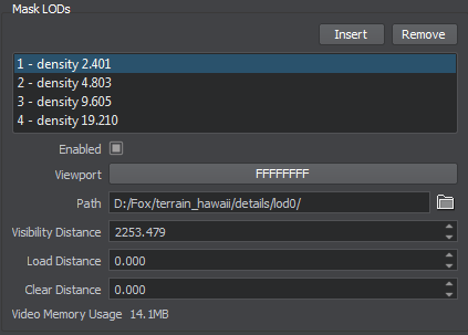
The following parameters are available for the Mask LODs:
- Enabled - enable or disable the current masks LOD.
- Viewport - viewport mask for the current masks LOD.
- Path - path to a folder, in which the current masks LOD is stored.
- Visibility distance - the distance starting from which the tiles of the current masks LOD become visible.
- Load distance - the distance starting from which the tiles of the current masks LOD are loaded into memory.
- Clear distance - the distance starting from which the tiles of the current masks LOD are removed from memory.
- Video memory usage - memory consumption of the current masks LOD.
Terrain Data Storage Format
Generated terrain data is stored in the specified folder with the following structure:
 detail masks
 heights
 imagery
 normals
 landcover masks for each type of generated landcover objects stored in separate folders with the corresponding names.
 vector_data masks for each type of generated vector objects stored in separate folders with the corresponding names.
Editing a Global Terrain
You can edit any height, albedo or mask LOD of the global terrain object using the Terrain Editor tool.
To start editing the current terrain, click the Edit button at the top of the Terrain Global tab of the Parameters window.

The Terrain Editor window will be displayed.
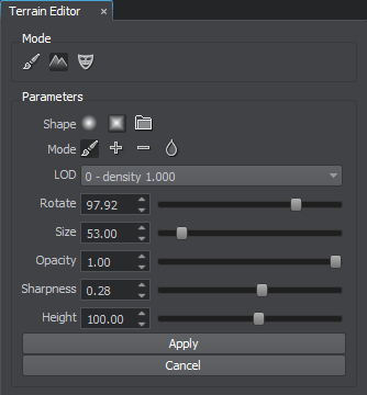
When you're done editing the terrain, click either Apply to apply all changes and exit the terrain editor, or Cancel to discard your changes.
Please refer to the Manual Terrain Modification article to learn more about manual terrain modification with brushes.
Global Terrain Physics Simulation
The terrain takes part in physics simulation if it has a standard surface_base property assigned. Collisions with physical bodies use the most detailed LOD 0 and are handled within a set distance, where simulation of physics is in effect.
Physical interaction can also be enabled for each of the height LODs by setting collision and intersection flags and masks.
Collisions are calculated for untesselated terrain geometry which may differ from the rendered geometry that is seen. Thus, in certain cases objects may seem "flying" above the terrain surface.
