生成地形和对象
您应该升级到
 As soon as you have added imagery and/or elevation, you are ready to generate a terrain.一旦您添加了照片和/或高程,您就可以生成地形了。
The Generation Settings panel is behind the Parameters panel and is accessible by switching the tabs.后面的Generation Settings面板Parameters面板,可以通过切换选项卡。
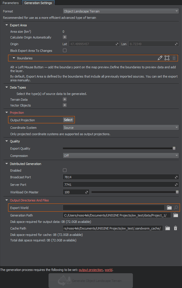
The items required to be set in order to start the terrain generation process, are highlighted red and displayed as clickable links at the bottom.设置所需的物品为了启动地形生成过程,突出显示红色,底部显示为可点击的链接。
Export AreaExport Area#
By default, all imported data are used to generate a terrain. It might take some time depending on the scope of your data.默认情况下,所有进口数据用于生成地形。它可能需要一些时间取决于您的数据的范围。
You can set boundaries for the export area to limit the generated terrain area.你可以设定界限的出口区域生成的地形限制区域。
Output ProjectionOutput Projection#
This is a projection based on which the terrain is generated.这是地形生成的基础投影。
As you click the Select button for Output Projection, the following window will open:当您单击 Output Projection 的 Select 按钮时,将打开以下窗口:
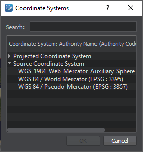
To begin with, double click the Source Coordinate System line and select EPSG:3857 — this is a projection widely used by such services as Google, OpenStreetMap, Navitel, etc. This projection fits almost all georeferenced data except poles.首先,双击Source Coordinate System行并选择EPSG:3857 -这是一个投影等服务广泛使用谷歌的OpenStreetMap Navitel等等。这个投影适合几乎所有地标数据除了两极。
For more details, see the setting description and the relevant FAQ section.有关详细信息,请参阅 设置 的说明和相关的 FAQ 部分。
Export WorldExport World#
Export World is a world where your terrain will be generated. If you have a world open in UNIGINE Editor, it would be set as the export world automatically. Otherwise, you'll need to (create and) select the world manually.Export World是一个世界,在那里你的地形将生成。如果你有一个世界开放UNIGINE Editor,它会被自动设置为出口世界。否则,您将需要手动选择世界。
Generating a Terrain生成地形#
If you don't have any issues highlighted red, click the Generate button below and wait until the generation process is finished. A generated terrain is available in the selected world.如果你没有任何问题突出红色,点击下面的Generate按钮,直到生成过程完成。生成的地形是在选定的世界上可用。
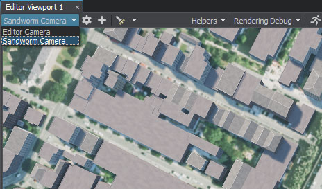
You can also generate only the selected type of data.您也可以只生成选定的数据类型。Switch to Sandworm Camera generated with a terrain to immediately observe the created terrain.切换到与地形一起生成的Sandworm Camera,立即观察创建的地形。
Generating Once Again再次生成#
Generate the terrain once again if you changed or added the data. You can also regenerate only the selected type of data.如果您更改或添加了数据,请再次生成地形。 您也可以只重新生成选定的数据类型。
If you changed anything in the generated assets manually (directly in UNIGINE Editor) and then regenerate them, all manual changes will be lost.如果你改变任何手动生成的资产(直接在UNIGINE Editor),然后重新生成它们,所有手动更改将丢失。
What Else还有什么#
- Frequently asked questions on Sandworm有关 Sandworm 的 常见问题
- Detailed information on all generation settings所有生成设置的详细信息