Sandworm界面
 This chapter gives an overview of the Sandworm tool interface.本章给出Sandworm工具接口的概述。
Opening the Sandworm Tool打开Sandworm工具#
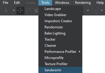
To open Sandworm, select Tools -> Sandworm in the main menu.要打开Sandworm,请在主菜单中选择Tools -> Sandworm。
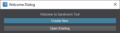
The following window will open:将打开以下窗口:
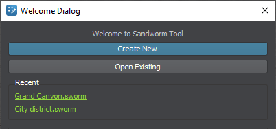
If you have already worked with Sandworm and created projects, you'll also see a list of links to your recent projects for quick access:如果您已经使用过Sandworm并创建过项目,您还会看到一个链接列表,链接到您最近的项目,以便快速访问:
By clicking the Create New button, the Project Configuration window opens:通过点击Create New按钮,Project Configuration窗口打开:
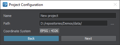
| Name | Sandworm project nameSandworm项目名称 |
|---|---|
| Path | Path to store the project存储项目的路径 |
| Coordinate System | Coordinate system used for the preview用于预览的坐标系统 |
The coordinate system you choose here is set for the convenience of preview display. For data export, you should specify only a projected coordinate system because the generated terrain is exported to Object Landscape Terrain or Object Terrain Global, which is a flat (i.e., not geospherical) area.此处所选择的坐标系统是为了便于预览显示而设置的。对于数据导出,您应该只指定 投影坐标系统,因为生成的地形被导出到Object Landscape Terrain或Object Terrain Global,这是一个平面(即,不是地球形)区域。
Sandworm InterfaceSandworm界面#
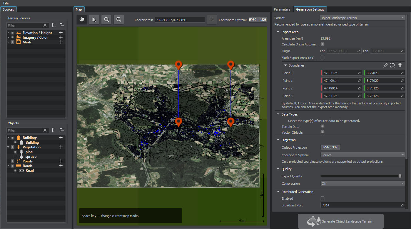
The Sandworm tool interface has five panels: Sources, Objects, Map, Parameters, and Generation Settings.Sandworm工具界面有五个面板:Sources, Objects, Map, Parameters和Generation Settings。
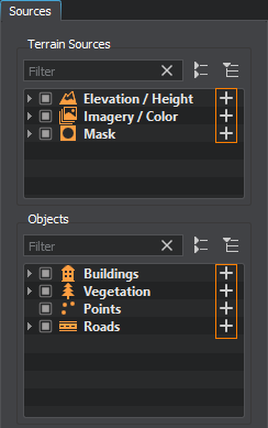
SourcesSources#
In the Sources panel, you specify the Elevation (height) and Imagery (albedo) sources for the terrain generation and the Mask data sources for details an vegetation generation, as well as objects that are placed on the terrain using the source data.在Sources面板中,为地形生成指定Elevation(高度)和Imagery(反照率)源,为植被生成的详细信息指定Mask数据源,以及使用源数据.放置在地形上的对象
To add a new data source or object, click the + sign for the corresponding source type:要添加新的数据源或对象,请单击对应数据源类型的+符号:
You can add multiple data sources. Thus, you can improve your data structure and manage all group members at once (enable/disable, add tags, modify parameters, etc.)您可以添加多个数据源。因此,您可以改进数据结构并同时管理所有组成员(启用/禁用、添加标记、修改参数等)。
The checkbox on the left of the source allows disabling a source, thus excluding it from the generation process.源代码左侧的复选框允许禁用一个源代码,从而将其从生成过程中排除。

Right-clicking on an item opens the context menu:右键单击一个项目打开上下文菜单:
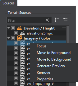
| Focus | Focuses the view in the Map panel on the selected source/object.将Map面板中的视图聚焦在所选的源/对象上。 |
|---|---|
| Move to Foreground | Moves the selected source/object (or several items of one type) to the foreground in the Map panel.将所选的源/对象(或同一类型的多个项)移动到Map面板的前台。 |
| Move to Background | Moves the selected source/object (or several items of one type) to the background in the Map panel.将所选的源/对象(或同一类型的多个项)移动到Map面板的后台。 |
| Generate Preview | Generates the preview of the selected source. It is designed to generate the preview that has previously been canceled.生成选定源的预览。 它旨在生成之前已取消的预览。 |
| Remove | Removes the selected source/object (or several items of one type). You can also delete a selected source/object by using the Delete button.删除所选的源/对象(或同一类型的多个项)。您还可以使用Delete按钮删除所选的源/对象。 |
| Properties | Displays the properties of the source file for the selected source, such as file name, the coordinate system the source file uses, the source file density in meters per pixel, and geographic bounds of the source file.显示源文件的属性选择的来源,如文件名、源文件使用的坐标系统,源文件在米/像素密度,和地理界限的源文件。 |
To rename a source/object, double-click its name. Renaming for objects is also available on the Parameters tab.要重命名源/对象,双击其名称。在Parameters选项卡上也可以重命名对象。
MapMap#
The Map panel visualizes the available information. Here you can navigate and preview the added inputs. The following controls are available:Map面板可视化信息。在这里您可以导航和预览输入补充道。以下控制:

 |
|
|---|---|
 |
Selection mode. Allows panning and selecting the foreground sources in the Map panel.选择模式。允许在Map面板中平移和选择前台源。 |
 |
Zoom-in button. The map can also be zoomed in by scrolling the mouse wheel up.放大缩小按钮。地图也可以通过滚动鼠标滚轮放大。 |
 |
Zoom-out button. The map can also be zoomed out by scrolling the mouse wheel down.长镜头按钮。也可以通过向下滚动鼠标滚轮来缩小地图。 |
| Coordinates | Current coordinates of the mouse cursor.目前鼠标光标的坐标。 |
 |
Display coordinates as WGS 84 latitude and longitude. If coordinates are already displayed as latitude and longitude (not in meters), this button is inactive.显示坐标为WGS 84纬度和经度。如果坐标已经显示为纬度和经度(而不是米),则此按钮无效。 |
| Coordinate System | The coordinate system selected for the Map panel. It can be changed by clicking this button.坐标系统选择Map面板。通过点击这个按钮可以改变。 |
The source data might be heavy, and it can take time to generate a preview. In this case, you can cancel the preview generation using the following button available in the bottom right corner of the Map panel during the generation process:the源数据可能是沉重的,它可以花时间来生成预览。在这种情况下,您可以使用下面的按钮取消预览生成可用Map面板右下角的生成过程:
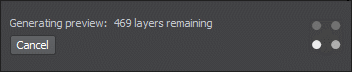
If you later require this preview to be generated, use the Generate Preview option in the context menu of the Sources panel.如果您稍后需要生成此预览,请使用Sources面板的上下文菜单中的Generate Preview选项。
ParametersParameters#
The Parameters panel contains parameters of the selected source or object.Parameters面板包含所选源或对象的参数。
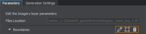
BoundariesBoundaries#
For the imported sources (elevation, imagery, masks, and vectors), you can set the area to be used for the terrain generation by adjusting the boundaries:对于导入的源(高程、图像、掩模和矢量),您可以通过调整边界来设置用于地形生成的区域:
 |
|
|---|---|
 |
|
 |
|
By using this toolset, you can define which data should be taken from every source without uploading any unnecessary or corrupted data.通过使用这个工具集,您可以定义应该从每个源获取哪些数据,而不上传任何不必要的或损坏的数据。
Generation SettingsGeneration Settings#
The Generation Settings panel contains the settings that define the details of the terrain generation process: the format of terrain, its size and form, type of projection, paths for storage and output, and the distributed generation settings.Generation Settings 面板包含定义 地形生成 过程细节的设置:地形的格式、大小和形式、投影类型、 存储和输出的路径,以及分布式生成设置。
If any parameters required for the generation have not been set, they are highlighted red in the bottom and clickable. Clicking on a highlighted word scrolls to the corresponding generation setting for adjustment.如果未设置生成所需的任何参数,则在底部以红色突出显示并可单击。点击一个高亮显示的单词,滚动到相应的生成设置进行调整。