Jump to content

Search the Community

Showing results for tags 'Height model'.

  • Search By Tags

    Type tags separated by commas.
  • Search By Author

Content Type


Forums

  • Welcome to UNIGINE Forums
    • News & Announcements
    • Getting started
  • Development
    • Content Creation
    • World Design
    • Rendering
    • Animation
    • Physics, Navigation and Path Finding
    • UI Systems
    • Sound & Video
    • Editor
    • C++ Programming
    • C# Programming
    • Networking
    • Sim IG (Image Generator)
    • VR Discussions
    • General
  • Improving UNIGINE
    • Documentation
    • Feedback for UNIGINE team
    • Bug Reports
    • Unigine SDK Beta feedback
  • Community
    • Add-on Store (https://store.unigine.com/)
    • Showcase
    • Collaboration
    • Tools, Plugins, Materials & Tutorials
    • General Discussions
  • Legacy
    • UnigineScript

Find results in...

Find results that contain...


Date Created

  • Start

    End


Last Updated

  • Start

    End


Filter by number of...

Found 1 result

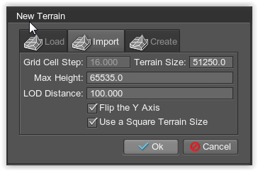
  1. Hi there We extract from different satellites data the height model. F.ex. a 50m resolution means that every pixel on a 1025x1025 picture corresponds to 50m. So the size of the patch is 51250m * 51250m and the height data is as well in meters. When I import this as a new terrain, I have to set the Terrain Size = 51250 and the Max Height = 65535, see the pictures as well. Otherwise, I get a missmatch in the units. In other areas we have a 1km resolution and there is the 1025x1025 picture around 1'025'000m * 1'025'000m... Is there a possibility to modify the units for lat/lon and height separately? I checked the Landscape plugin as well, and there I see the same problem with the units. Thanks for
×
×
  • Create New...